
One of the most rewarding aspects of being an OpenStreetMap contributor is the surprise of discovering where your contributions will be displayed next.
“I put that obscure, forgotten place back on the map, and now they’re everywhere!”
Researching toponyms is fun because I have to analyze the daily conversations among the locals and try to triangulate the place name centroid based on this conversations. Bonus point if my centroid triangulation somehow coincides with ancient, forgotten, historical maps.
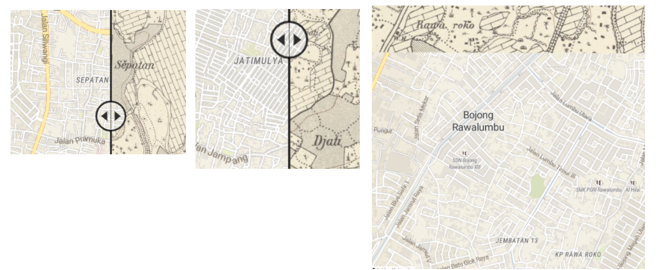
Traces of Sepatan, Djati, and Rawa Roko can still be found on old historical maps, circa 1900. Locals still use these toponyms right now, despite the government’s refusal to acknowledge their existence in the official addressing system.
It’s ‘forgotten’ in the sense that the local government over here has simplified the toponym system too much. Some toponyms have been upgraded to official administrative region names (and are now embedded in the official addressing system), while the rest have been left behind. People still use these ‘left-behind’ toponyms daily to refer to certain places, even though the government has somewhat ‘discouraged’ their use. (The colonial administration did it better, though. When I consulted the archives and library for old maps, all of these ‘left-behind’ toponyms were actually mapped quite well in the past.)
And this situation has led to mass confusion for people. Government-mandated addresses often don’t reflect reality. People still use all those ‘left-behind’ toponyms in their daily activities, yet they don’t appear on official, government-mandated maps and addressing systems.
That’s one of my personal missions right now: to put all those ‘left-behind’ toponyms back on the maps.
Discussion
Comment from darkonus on 29 April 2024 at 18:28
I stumbled upon your post by chance, and I must say I completely resonate with your thoughts. Like you, I’ve been documenting local place names in several towns. Initially, I only knew a few, but after talking to several people, I discovered there are many more. Just like in your case, only a few toponyms are reflected in the official street names, while most of these names are slowly being forgotten.
Another interesting fact is that sometimes these toponyms are so “tiny” that different parts of the same street have their own names. For example, a village with five official street names has nine micro-toponyms that people constantly use in conversations at shops, markets, and so on.
Sometimes, I even came across mentions of these toponyms in the local press. Headlines like “Planned repair of the heating network will start in the ‘Bayraki’ microdistrict on May 10th” show how widespread these names are among locals, even though they don’t have any official status. Another time, I found a mention of a locality name in the transcript of a court hearing about a minor theft, which both surprised and amused me. It’s fascinating to see how deeply ingrained these names are in the local culture and everyday life, even making their way into official announcements and legal documents.
It’s a wonderful and valuable effort in preserving the history of the town. Keep up the great work!
Comment from rtnf on 30 April 2024 at 00:25
Daily conversations, local businesses’ addresses shown on ads and banners, local news, and court hearings are several possible sources to investigate local toponyms. :)
Comment from arukuni on 7 May 2024 at 08:28
That’s awesome, how did you achieve these effect you can see in the image - comparing old and new maps?
Comment from rtnf on 7 May 2024 at 08:37
@arukuni
https://www.oldmapsonline.org/